
RIVF 2026 International Conference on Computing and Communication Technologies
Rack-to-Bin
Hierarchical localization and visual refinement for autonomous UAV warehouse inspection
VNU University of Engineering and Technology (T. N. Canh also with JAIST) *Corresponding author
01 · Abstract
One rack tag, every bin, without GPS
Autonomous UAVs offer a flexible way to inspect inventory in indoor warehouses, where GPS is often unavailable and storage racks stand in narrow aisles. This paper presents an integrated UAV inspection system built on a fiducial-anchored coarse-to-fine strategy.
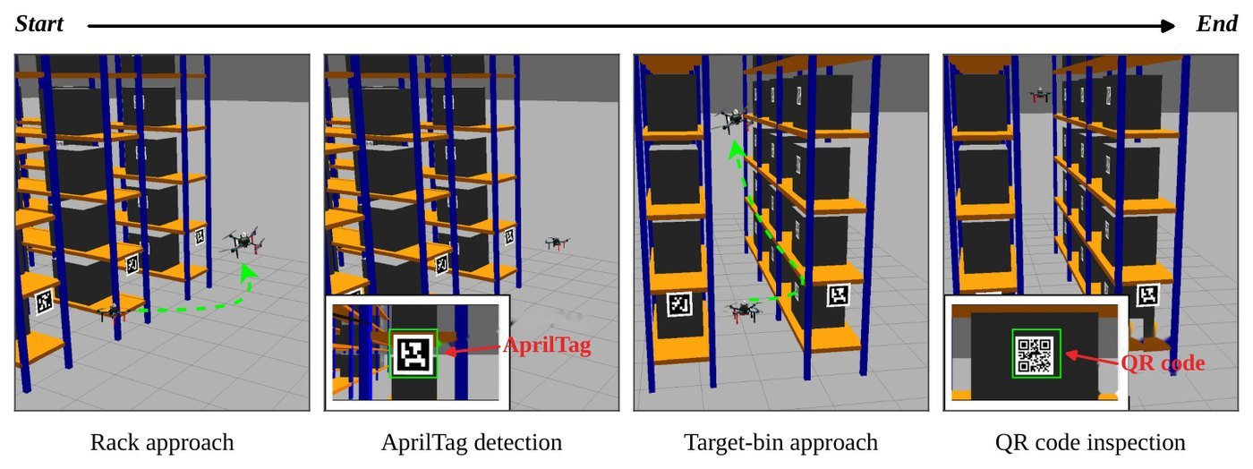
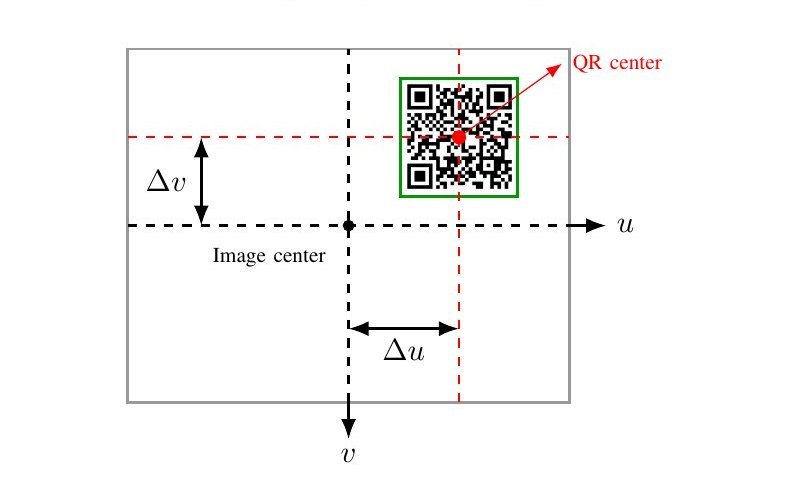
The UAV first navigates toward the target rack using a LiDAR-based OctoMap and a collision-aware path planner. At the rack, a rack-level AprilTag is detected and combined with the known rack geometry to estimate the nominal position of the selected bin. Because small position errors can remain after global navigation, a proportional visual-servoing step uses the QR code's position in the camera image to refine the final inspection pose before decoding.
In a custom Gazebo warehouse with narrow aisles, under Point-LIO localization, the method raises the capture success rate from 10.42% to 86.05% of eligible trials and reduces the mean per-axis capture error to about 2.3 cm. Local visual refinement further reduces the image-space alignment error from 212.67 to 24.34 pixels.
02 · Video
Watch the inspection mission
03 · Method
Coarse to fine: rack, then bin, then image
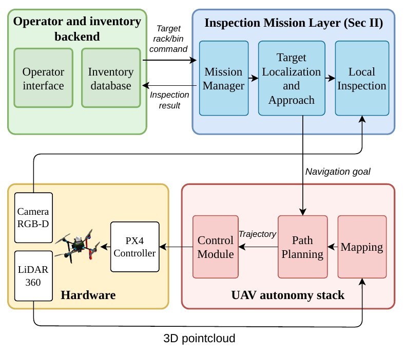
- 1
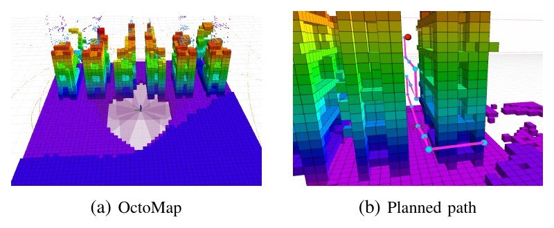
Collision-aware navigation
A LiDAR OctoMap and an A* planner take the UAV through narrow aisles to the target rack, with a reactive bumper as a safety layer.
- 2
Rack-level anchor
One AprilTag per rack, plus the known rack geometry, gives the nominal inspection pose of every bin on that rack.
- 3
Boustrophedon sequence
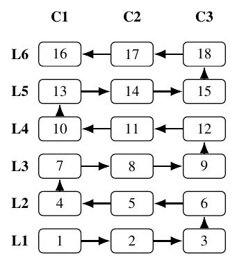
Bins on a rack are visited in a snake-like (boustrophedon) order, column by column along each level.
- 4
Visual servoing on the QR code
A proportional controller centres the bin's QR code in the camera image, absorbing the error left by global localization.
- 5
Decode and verify
The decoded QR payload is checked against the inventory database: matched, mismatched or unread.
- 6
Real-platform design
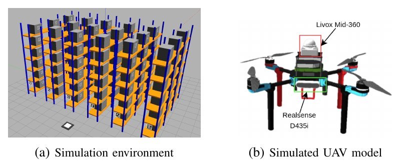
The simulated UAV mirrors a Pixhawk 6X + PX4 drone with a Jetson Orin NX, Livox Mid-360 LiDAR and RealSense D435i camera.
04 · E1 · Capture accuracy
How close does the UAV get to each bin?
54 requested bins per variant. A capture succeeds when the horizontal and vertical errors are both under 5 cm. Pick the localization source and a metric.
Servoing roughly doubles the time per bin (about 9–10 s instead of 4–7 s), and some bins are never reached: success over all 54 requested bins is 76% (GNSS) and 69% (Point-LIO).
05 · E2 · Narrow aisles
Safety versus reaching the goal
30 paired trials per configuration. Collision-free counts trials without contact; success also requires reaching the goal within 0.60 m in 20 s.
The planner makes flight far safer (96.7–100% collision-free) but does not raise goal success, and a large bumper distance (1.0 m) causes conflicting corrections in tight aisles. The A* planner and threshold bumper are deliberately simple and can be swapped for stronger planners.
06 · E3 · QR inspection
Centring the QR code before reading it
Local alignment cuts the alignment error from 212.67 to 24.34 px, but the nominal pose already decodes 100% of codes, so the gain is viewpoint accuracy rather than decoding rate, at about 11 s per bin.
07 · Cite
Citation
@inproceedings{nguyen2026racktobin,
  title     = {Rack-to-Bin Hierarchical Localization and Visual Refinement for Autonomous UAV Warehouse Inspection},
  author    = {Nguyen, Van Tong and Tran Viet, Thang and Nguyen, Van Bang and HoangVan, Xiem and Nguyen Canh, Thanh},
  booktitle = {RIVF International Conference on Computing and Communication Technologies (RIVF)},
  year      = {2026}
}